


Road closure causes concern about bus routes
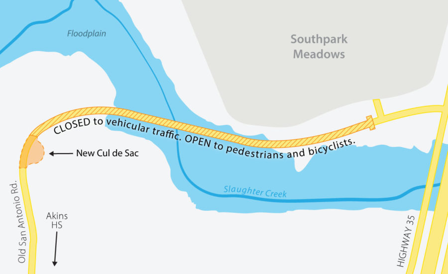
The City of Austin’s Watershed Protection office announced in late March that the city would be closing a section of Old San Antonio Road near Akins High School that includes a dangerous hilly curve and low-water crossing that floods during heavy rains. The city considered different solutions for this dangerous area before settling on road closure.
April 18, 2019
Almost everyone on campus has an Old San Antonio Road story.
They often revolve around how dangerous it is for pedestrians and drivers. Its sharp turn, hilly terrain and lack of shoulders can make the most confident think twice about traversing it. Over the past school year, two students have been hit by drivers coming up the road in front of the bus loop.
Principal Tina Salazar said her vehicle has been hit while driving on Old San Antonio Road about seven years ago. She said that the road was slick, and another driver hit her.
“This car was coming and I was trying to get away from him,” Salazar said. “He slid right into me.”
Because of the traffic danger and the high risk of the low water crossing, the City of Austin has decided to close the road in the fall of 2019. The low-water crossing is the major prompt for the change; the street can get flooded to over 16 feet during heavy downpours, and it is one of the 10 most dangerous crossings in the city.
Project manager Reem Zoun said that Watershed Protection for the city considered different solutions for this dangerous area before settling on road closure.
“We looked at different bridge options to upgrade that low-water crossing into a bridge which would have been much higher,” Zoun said. “We looked at food warning gate arm and we looked at closing the roadway and eventually providing an alternate route.”
Sophomore Malachi Chambers said that he’s used the road as a shortcut to Southpark Meadows in the past. He said that while it feels more natural and is a shorter route, he’s been close to getting hit before.
“It wasn’t exactly the safest option,” Chambers said. “Around the turn is probably the most dangerous part.”
Old San Antonio Road will only be closed to vehicles. It will be accessible to pedestrians and bikes, and there will be an unlockable gate for emergency vehicles. In addition to the closure of Old San Antonio Road, a cul-de-sac will be built on the west side of the closure and there are early plans to extend Brezza Lane and install a traffic signal on FM 1626.
Zoun said that the feedback she’s heard about these changes from nearby residents and Akins community members has been largely positive.
Salazar said that she doesn’t know what the buses will do next year before the extension of Brezza Lane. The buses rely heavily on the road, leaving and arriving before and after school on the street to make their way to Interstate 35. Salazar said that she’s thought about multiple options, but isn’t sure what the route of arrival and departure will be next year.
“It’s going to be a huge transition for us,” Salazar said. “I wish they would shut it down at the end of July (instead of in the fall), but they’re not going to.”